
New Romney
| Civil parish in Engeland | |||
|---|---|---|---|
 | |||
| Situering | |||
| Regio | South East England | ||
| Graafschap | Kent | ||
| District | Folkestone & Hythe | ||
| Coördinaten | 50° 59' NB, 0° 57' OL | ||
| Algemeen | |||
| Oppervlakte | 6,4145 km² | ||
| Inwoners (2011) |
6996 (1091 inw./km²) | ||
| Overig | |||
| Postcode(s) | TN28 | ||
| Netnummer(s) | 01797 | ||
| Grid code | TR066249 | ||
| Post town | TONBRIDGE | ||
| ONS-code | E04005028 | ||
| Foto's | |||

| |||
| High Street | |||
| |||
New Romney is een civil parish in het bestuurlijke gebied Folkestone & Hythe, in het Engelse graafschap Kent. De plaats telt 6996 inwoners.
Het is het hoofdkwartier van de Romney, Hythe and Dymchurch Railway.
-
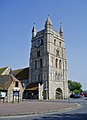 Kerk in New Romney

| Bronnen, noten en/of referenties |
Geplaatst op:
14-07-2007 |
Dit artikel is een beginnetje over landen & volken. U wordt uitgenodigd om op bewerken te klikken om uw kennis aan dit artikel toe te voegen. |