
Bestand:Montjuïc circuit.svg

Afmetingen van deze voorvertoning van het type PNG van dit SVG-bestand: 800 × 531 pixels Andere resoluties: 320 × 212 pixels | 640 × 425 pixels | 1.024 × 680 pixels | 1.280 × 850 pixels | 2.560 × 1.700 pixels | 1.512 × 1.004 pixels.
Oorspronkelijk bestand (SVG-bestand, nominaal 1.512 × 1.004 pixels, bestandsgrootte: 318 kB)
| Dit is een bestand van Wikimedia Commons. Onderstaande beschrijving komt van de beschrijving van het bestand daar. |
Beschrijving
| Beschrijving |
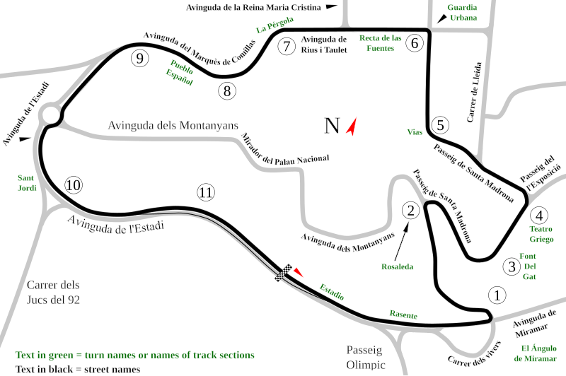
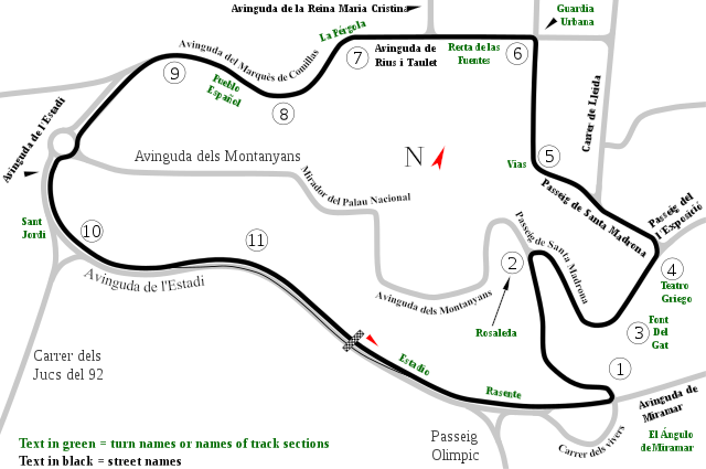
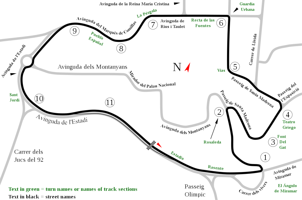
English: Track map of Montjuïc circuit. Gray lines are streets. Green text are either turn names or track section names. Black text (with out the circle) are street names. |
| Datum | |
| Bron | Eigen werk |
| Auteur | Will Pittenger |
| Andere versies |
|

| Cameralocatie | | Deze en andere afbeeldingen in: OpenStreetMap |
|---|
Licentie
| Ik, de auteursrechthebbende van dit werk, geef dit werk vrij in het publieke domein. Dit is wereldwijd van toepassing. In sommige landen is dit wettelijk niet mogelijk; in die gevallen geldt: Ik sta iedereen toe dit werk voor eender welk doel te gebruiken, zonder enige voorwaarden, tenzij zulke voorwaarden door de wet worden voorgeschreven. |
Bestandsgeschiedenis
Klik op een datum/tijd om het bestand te zien zoals het destijds was.
| Datum/tijd | Miniatuur | Afmetingen | Gebruiker | Opmerking | |
|---|---|---|---|---|---|
| huidige versie | 19 jul 2008 14:55 | | 1.512 × 1.004 (318 kB) | Will Pittenger | Once again, please use the previous version if you need to edit the file. |
| 19 jul 2008 14:54 |  | 1.512 × 1.004 (128 kB) | Will Pittenger | Corrected typos. The text objects that were on paths are back on paths. | |
| 19 jul 2008 14:20 |  | 1.512 × 1.004 (318 kB) | Will Pittenger | Mediawiki/RSVG has problems with text on paths. It tends to hide such text objects. This version gets around that bug by converting such objects to paths. If you need to edit the file, please use the previous version. | |
| 19 jul 2008 14:17 |  | 1.512 × 1.004 (128 kB) | Will Pittenger | New version has keywords added. | |
| 19 jul 2008 13:58 |  | 1.512 × 1.004 (127 kB) | Will Pittenger | This version fixes the document size. | |
| 19 jul 2008 13:54 |  | 744 × 1.052 (126 kB) | Will Pittenger | {{Information |Description={{en|1=Track map of w:Montjuïc circuit. Gray lines are streets. Green text are either turn names or track section names. Black text (with out the circle) are street names.}} |Source=Own work by uploader |Author=[[User:W |
Bestandsgebruik
Dit bestand wordt op de volgende 16 pagina's gebruikt:
- Grand Prix-wegrace van Spanje 1953
- Grand Prix-wegrace van Spanje 1954
- Grand Prix-wegrace van Spanje 1955
- Grand Prix-wegrace van Spanje 1961
- Grand Prix-wegrace van Spanje 1962
- Grand Prix-wegrace van Spanje 1963
- Grand Prix-wegrace van Spanje 1964
- Grand Prix-wegrace van Spanje 1965
- Grand Prix-wegrace van Spanje 1966
- Grand Prix-wegrace van Spanje 1967
- Grand Prix-wegrace van Spanje 1968
- Grand Prix-wegrace van Spanje 1970
- Grand Prix-wegrace van Spanje 1972
- Grand Prix-wegrace van Spanje 1974
- Grand Prix-wegrace van Spanje 1976
- Lijst van Formule 1-circuits
Globaal bestandsgebruik
De volgende andere wiki's gebruiken dit bestand:
- Gebruikt op af.wikipedia.org
- Gebruikt op ar.wikipedia.org
- Gebruikt op ast.wikipedia.org
- Gebruikt op bg.wikipedia.org
- Gebruikt op bn.wikipedia.org
- Gebruikt op br.wikipedia.org
- Gebruikt op ca.wikipedia.org
- Circuit de Montjuïc
- 24 Hores de Montjuïc
- Gran Premi d'Espanya de motociclisme de 1964
- Gran Premi d'Espanya de motociclisme de 1965
- Gran Premi d'Espanya de motociclisme de 1966
- Gran Premi d'Espanya de motociclisme de 1968
- Gran Premi d'Espanya de motociclisme de 1974
- Gran Premi d'Espanya de motociclisme de 1961
- Gran Premi d'Espanya de motociclisme de 1962
- Gran Premi d'Espanya de motociclisme de 1963
- Gran Premi d'Espanya de motociclisme de 1967
- Gran Premi d'Espanya de motociclisme de 1970
- 24 Hores de Montjuïc 1961
- 24 Hores de Montjuïc 1962
- 24 Hores de Montjuïc 1965
- 24 Hores de Montjuïc 1968
- 24 Hores de Montjuïc 1973
- 24 Hores de Montjuïc 1977
- 24 Hores de Montjuïc 1979
- 24 Hores de Montjuïc 1981
- 24 Hores de Montjuïc 1982
- 24 Hores de Montjuïc 1984
- 24 Hores de Montjuïc 1985
- Gebruikt op cs.wikipedia.org
- Gebruikt op de.wikipedia.org
- Gebruikt op en.wikipedia.org
Globaal gebruik van dit bestand bekijken.