
Gebruiker:Koektrommel/test


De geografie van Indonesië wordt gedomineerd door vulkanen. De vulkanen zijn en worden gevormd door subductie tussen de Euraziatische Plaat en de Indo-Australische Plaat. Een aantal van deze vulkanen staan bekend vanwege de (heftige) uitbartingen, bijvoorbeeld, Krakatau vanwege de wereldwijde klimaatverandering in 1883.[1] Tobameer vanwege de supervulkanische uitbarsting, zo'n 74.000 jaar v. Chr., welke zorgde voor een vulkanische winter van zes jaar[2] en Tambora vanwege de grootste uitbarsting ooit vastgelegd in 1815.[3]
Vulkanen in Indonesië maken deel uit van de Pacific Ring of Fire. De 150 vulkanen in de lijst hieronder zijn verdeeld in zes geografische regio's. Vier daarvan mnaken deel uit van de eilandboog van de Soenda-eilanden. De overige twee groepen zijn de vulkanen van Halmahera, inclusief de omliggende vulkanische eilanden, en de vulkanen van Celebes en de eilanden van Sangihe. De laatste groep is een vulkanische boog tezamen met de vulkanen van de Filipijnen.
De meest actieve vulkanen zijn de Kelud en de Merapi op het eiland Java, welke verantwoordelijk zijn geweest voor duizenden doden in die regio. Since AD 1000, Kelud has erupted more than 30 times, of which the largest uitbarsting was at scale 5 on the Vulkanische-explosiviteitsindex (VEI),[4] while Merapi has erupted more than 80 times.[5] The International Association of Volcanology and Chemistry of the Earth's Interior has named Merapi as a Decade Volcano since 1995 because of its high volcanic activity.
Scope
[bewerken | brontekst bewerken]There is nee single standard definition for a volcano. It can be defined from individual vents, volcanic edificies or volcanic fields. Interior of ancient vulkanen may have been eroded, creating a new subsurface magma chamber as a separate volcano. Many contemporary active vulkanen rise as young parasitic cones from flank vents or at a central crater. Some slakkenkegels are grouped into one volcano name, for instance, the Tengger caldera complex, although individual vents are named by local people. The status of a volcano, either active or dormant, cannot be defined precisely. An indication of a volcano is determined by either its historical records, radiocarbon dating, or geothermal activities.
The primary source of the lijst below is taken from the "Volcanoes of the World" book, compiled by two volcanologists Tom Simkin and Lee Siebert,[noot 1] in which active vulkanen in the past 10,000 years (Holocene) are listed.[6] Particularly for Indonesia, Simkin and Siebert used a catalogue of active vulkanen from the International Association of Volcanology and Chemistry of the Earth's Interior publication series.[noot 2] The Simkin and Siebert lijst is the most complete lijst of vulkanen in Indonesia, but the accuracy of the record varies from one region to another in terms of contemporary activities and fatalities in recent uitbarstings. Complementary sources for the latest volcanic data are taken from the Volcanological Survey of Indonesia, a governmental institution which is responsible for volcanic activities and geological hazard mitigation in Indonesia,[7] and some academic resources.
Geographical groups
[bewerken | brontekst bewerken]Sumatra
[bewerken | brontekst bewerken]
The geography of Sumatra is dominated by a mountain range called Bukit Barisan (lit: "a row of hills"). The mountain range spans nearly 1.700 km (1.050 mi) from the north to the south of the island, and it was formed by movement of the Australian tectonic plate.[8] The plate moves with a convergence rate of 5.5 cm/year which has created major earthquakes on the western side of Sumatra including the 2004 Sumatra-Andaman earthquake.[9][10] The tectonic movement has been responsible not only for earthquakes, but also for the formulation of magma chambers beneath the island.[8]
Only one of the 35 active volcanos, Weh, is separated from the Sumatran mainland. The separation was caused by a large uitbarsting that filled the lowland between Weh and the rest of the mainland with sea water in the Pleistoceen epoch. The largest volcano of Sumatra is the supervulkaan Tobameer within the 100 km (62 miles) × 30 km (19 miles) Tobameer, which was created after a caldera collapse (est. in 74.000 Before Present).[2] The uitbarsting is estimated to have been at level eight on the VEI scale, the largest possible for a volcanic uitbarsting. The highest peak of the mountain range is Kerinci with an elevation of 3.800 m (12.467 ft).


Straat Soenda en Java
[bewerken | brontekst bewerken]The Straat Soenda separates the islands of Sumatra and Java with the volcanic island Krakatau lying between them. Krakatau erupted violently in 1883. destroying two-thirds of the island and leaving a large caldera under the sea. This cataclysmic explosion was heard as far away as the island of Rodrigues near Mauritius (approx. 3000 miles or 4800 km away).[1] A new parasitic cone, called Anak Krakatau (or the child of Krakatau), rose from the sea at the center of the caldera in 1930.[12] The other Krakatau islets from the 1883 uitbarstings are known as Sertung, Panjang and Rakata.
Java is a relatively small island compared to Sumatra, but it has a higher concentration of active vulkanen. There are 45 active vulkanen on the island excluding 20 small craters and cones in the Dieng vulkaancomplex and the young cones in the Tengger caldera complex. Some vulkanen are grouped together in the lijst below because of their close location. Merapi, Semeru and Kelud are the most active vulkanen in Java. Semeru has been continuously erupting since 1967.[13] Merapi has been named as one of the Decade Vulkanen since 1995.[14] Ijen has a unique colorful caldera lake which is an extremely acidic natural reservoir (pH<0.3).[15] There are sulfur mining activities at Ijen, where miners collect highly concentrated sulfur rocks by hand.
-
 Tangkuban Perahu, taken from the above.
 -
 Lightning strikes during the 1982 Galunggung uitbarsting.
 -
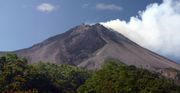 Merapi, the most active volcano in Indonesia.
 -

-


Kleine Soenda-eilanden
[bewerken | brontekst bewerken]De archipel Kleine Soenda-eilanden bestaan uit, van west naar oost, Bali, Lombok, Sumbawa, Flores, Sumba en Timor. Deze liggen allemaal aan de rand van de Indo-Australische Plaat. Vulkanen in deze regio worden gevormd door de oceanische lithosfeer en door het bewegen van de plaat zelf.[19] Een aantal vulkanen vormen een compleet eiland, zoals het eiland Sangeang Api. Tambora, gesitueerd op het eiland Sumbawa, barstte uit op 5 april 1815, met een kracht van 7 op de VEI en wordt gezien als de krachtigste uitbarsting ooit vastgelegd.[3]


Bandazee
[bewerken | brontekst bewerken]De Bandazee in het zuiden van de Molukse archipel omvat een kleine eilandengroep, de Banda-eilanden. Drie belangrijke tektonische platen onder de zee, de Euraziatische Plaat, de Pacifische Plaat en de Indo-Australische Plaat convergeren (komen naar elkaar toe) sinds het Mesozoïcum, hierdoor ontstaan vulkanen.[21] Vulkanenin in de Bandazee zijn voornamelijk vulkanische eilanden, maar er zijn ook een aantal submariene vulkanen.
| Naam | Type | Hoogte | Laatste uitbarsting (VEI) | Lokatie | |
|---|---|---|---|---|---|
| (m) | (ft) | ||||
| Emperor of China | submarien | -2.850 | -9.350 | onbekend | 6° 37' 12" ZB, 124° 13' 12" OL |
| Nieuwerkerk | submarien | -2.285 | -7.500 | onbekend | 6° 35' 60" ZB, 124° 40' 30" OL |
| Genungapi Wetar | stratovulkaan | 282 | 925 | 1699 (3) | 6° 38' 31" ZB, 126° 39' 0" OL |
| Wurlali | stratovulkaan | 868 | 2.850 | 3 juni 1892 (2) | 7° 7' 30" ZB, 128° 40' 30" OL |
| Teon | stratovulkaan | 655 | 2.150 | 3 juni 1904 (2) | 6° 55' 12" ZB, 129° 7' 30" OL |
| Nila | stratovulkaan | 781 | 2.500 | 7 mei 1968 (1) | 6° 43' 48" ZB, 129° 30' 0" OL |
| Serua | stratovulkaan | 641 | 2.100 | 18 september 1921 (2) | 6° 17' 60" ZB, 130° 0' 0" OL |
| Manuk | stratovulkaan | 282 | 925 | onbekend | 5° 31' 48" ZB, 130° 17' 31" OL |
| Gunung Api | caldera | 640 | 2.100 | 9 mei 1988 (3) | 4° 31' 30" ZB, 129° 52' 16" OL |
Celebes and Sangihe Islands
[bewerken | brontekst bewerken]Four peninsulas dominate the shape of Celebes island (formerly known as Celebes). The central part is high mountaineous area, but mostly non-volcanic. Active vulkanen are found in the northern peninsula and continuously stretches to the north to Sangihe Islands. The Sangihe Islands marks the border with Philippines.
Halmahera
[bewerken | brontekst bewerken]Halmahera island in the north of Molucca archipelago has been formed by the movement of three tectonic plates resulting in two intersecting mountain ranges, which form four rocky peninsulas separated by three deep bays. A volcanic arc stretches from north to south in the west side of Halmahera, some of which are volcanic islands, for instance, Gamalama and Tidore. Gamalama's island name is Ternate and it has been the center for spice trading since the Portuguese Empire opened a fort in 1512. Due to its location as the center for spice trading during the Age of Discovery, historical records of volcanic uitbarstings in Halmahera have been available as far back as the early 16th century.

De grootste uitbarstingen
[bewerken | brontekst bewerken]Op de lijst hieronder staan de grootste vulkaanuitbarstingen van Indonesië, chronologisch gesorteerd op de startdatum van de uitbarsting. Alleen uitbarstingen met schaal 3 of hoger op de VEI en uitbarstingen met (veel) slachtoffers staan op de lijst.
| Start uitbarsting |
Vulkaan | Einde uitbarsting |
VEI | Eigenschappen | Tsunami | Tephra volume | Slachtoffers | Bronnen |
|---|---|---|---|---|---|---|---|---|
| 20 jan 1992 | Merapi | 19 okt 2002 | 2 | cv,pf,ld,lm | nee | N/A | 66 | [5] |
| 10 feb 1990 | Kelud | maa 1990 | 4 | cv,cl,pf,ph,ld,lm | nee | 0.13 km³ | 35 | [26] |
| 18 jul 1983 | Colo | dec 1983 | 4 | cv,pf,ph | nee | N/A | 0 | [26] |
| 5 apr 1982 | Galunggung | 8 jan 1983 | 4 | cv,pf,lf,lm | nee | > 0.37 km³ | 68 | [27][28] |
| 6 okt 1972 | Merapi | maa 1985 | 2 | cv,pf,lf,ld,lm | nee | 0.021 km³ | 29 | [5] |
| 26 apr 1966 | Kelud | 27 apr 1966 | 4 | cv,cl,pf,lm | nee | 0.089 km³ | 212 | [26] |
| 17 maa 1963 | Agung | 27 jan 1964 | 5 | cv,pf,lf,lm | nee | 1 km³ | 1.148 | [29] |
| 31 aug 1951 | Kelud | 31 aug 1951 | 4 | cv,cl,pf,lm | nee | 0.2 km³ | 7 | [26] |
| 25 nov 1930 | Merapi | sep 1931 | 3 | cv,rf,pf,lf,ld,lm | nee | 0.0017 km³ | 1.369 | [5] |
| 19 mei 1919 | Kelud | 20 mei 1919 | 4 | cv,cl,pf,lm | nee | 0.19 km³ | 5.110 | [26] |
| 7 jun 1892 | Awu | 12 jun 1892 | 3 | cv,pf,lm | ja | N/A | 1.532 | [30] |
| 26 aug 1883 | Krakatau | feb 1884 | 6 | cv,se,pf,fa,lm,cc | 15–42 m | 5–8.5 km³ | 36.600 | [1][29][31] |
| 15 apr 1872 | Merapi | 21 apr 1872 | 4 | cv,pf | nee | 0.33 km³ | 200 | [5] |
| 2 maa 1856 | Awu | 17 maa 1856 | 3 | cv,pf,lm | ja | 0.51±0.50 km³ | 2.806 | [30] |
| 8 okt 1822 | Galunggung | dec 1822 | 5 | cv,pf,ld,lm | nee | > 1 km³ | 4.011 | [26] |
| 10 apr 1815 | Tambora | 15 jul 1815 | 7 | cv,pf,cc | 1–2 m | 160 km³ | > 71.000 | [3][32] |
| 6 aug 1812 | Awu | 8 aug 1812 | 4 | cv,pf,lm | nee | 0.55±0.50 km³ | 963 | [30] |
| 12 aug 1772 | Papandayan | 12 aug 1772 | 3 | cv,ph | nee | N/A | 2.957 | [33] |
| 4 aug 1672 | Merapi | onbekend | 3 | cv,pf,lm | nee | N/A | 3.000 | [5] |
| 1586 | Kelud | onbekend | 5 | cf,cl,lm | nee | > 1 km³ | 10,000 | [26] |
| ≈ 74.000 BP | Tobameer | onbekend | 8 | pf,lf,cc | mogelijk | 2.800 km³ | near extinction of human population |
[2] |
Notes: cv=central vent uitbarsting, pf=pyroclastic flows, lf=lava flows, lm=lahar mudflows, cl=crater lake uitbarsting, ph=phreatic uitbarsting, ld=lavakoepel extrusion, cc=caldera collapse, se=submarien uitbarsting, fa=fumarole activity, rf=radial fissure uitbarsting.
Externe links
[bewerken | brontekst bewerken]- (en) Volcanological Survey Indonesia
- (en) Tectonics of Indonesia
- (en) Indonesian Vulkanen and mountains of Indonesia
- ↑ (en) Tom Simkin and Lee Siebert (1994). Volcanoes of the World: A Regional Directory, Gazetteer, and Chronology of Volcanism During the Last 10,000 Years, 2nd. Geoscience Press. ISBN 0945005121.
- ↑ (en) M. Neumann van Padang (1951). Indonesia, 1. IAVCEI, Rome, 1–271.
- ↑ a b c (en) Winchester, Simon (2003). Krakatoa: The Day the World Exploded: augustus 27. 1883. HarperCollins. ISBN 0-06-621285-5.
- ↑ a b c (en) Oppenheimer, C. (2002). Limited global change due to the largest known Quaternary eruption, Toba ≈74 kyr BP?. Quarternary Science Reviews 21 (14–15): 1593–1609. DOI: 10.1016/S0277-3791(01)00154-8.
- ↑ a b c (en) Stothers, Richard B. (1984). The Great Tambora Eruption in 1815 and Its Aftermath. Science 224 (4654): 1191–1198. PMID 17819476. DOI: 10.1126/science.224.4654.1191.
- ↑ (en) Kelud Eruptive History. Global Volcanism Program. Smithsonian Institution. Geraadpleegd op 19 december 2006.
- ↑ a b c d e f (en) Merapi Eruptive History. Global Volcanism Program. Smithsonian Institution. Geraadpleegd op 19 december 2006.
- ↑ (en) Summary Data Criteria. Global Volcanism Program. Smithsonian Institution. Geraadpleegd op 31 december 2006.
- ↑ a b (en) Centre of Volcanology & Geological Hazard Mitigation. Volcanological Survey of Indonesia. Geraadpleegd op 31 december 2006.
- ↑ a b (en) Simoes, M., Avouac, J.P., Cattin, R., Henry, P. (2004). The Sumatra subduction zone: A case for a locked fault zone extending into the mantle (PDF). Journal of Geophysical Research 109: B10402. DOI: 10.1029/2003JB002958.
- ↑ (en) Subarya, C., Chlieh, M., Prawirodirdjo, L., Avouac, J.P., Bock, Y., Sieh, K., Meltzner, A., Natawidjaja, D.H., McCaffrey, R. (2006). Plate-boundary deformation associated with the great Sumatra-Andaman earthquake (PDF). Nature 440 (7080): 46–51. PMID 16511486. DOI: 10.1038/nature04522.
- ↑ (en) Lay, T., Kanamori, H., Ammon, C., Nettles, M., Ward, S., Aster, R., Beck, S., Bilek, S., Brudzinski, M., Butler, R., DeShon, H., Ekstrom, G. (2005). The Great Sumatra-Andaman Earthquake of 26 december 2004 (PDF). Science 308 (5725): 1127–1133. PMID 15905392. DOI: 10.1126/science.1112250.
- ↑ (en) Volcanoes of Indonesia - Sumatra. Global Volcanism Program. Smithsonian Institution. Geraadpleegd op 17 november 2006.
- ↑ (en) Whittaker, R. J., Bush, M. B. (1993). Anak Krakatau and old Krakatau: a reply. GeoJournal 29 (4): 417–420. DOI: 10.1007/BF00807545.
- ↑ (en) Semeru Weekly Reports. Global Volcanism Program. Smithsonian Institution. Geraadpleegd op 7 december 2006.
- ↑ (en) International Association of Volcanology and Chemistry of the Earth's Interior (1995). Decade Volcano Update. Bulletin of Volcanology 57 (1): 82–83. DOI: 10.1007/BF00298711.
- ↑ (en) Ansje Löhr, Thom Bogaard, Alex Heikens, Martin Hendriks, Sri Sumarti, Manfred van Bergen, Kees C.A.M. van Gestel, Nico van Straalen, Pieter Vroonand, and Budi Widianarko (2005). Natural Pollution Caused by the Extremely Acid Crater Lake Kawah Ijen, East Java, Indonesia. Environmental Science and Pollution Research 12 (2): 89–95. DOI: 10.1065/espr2004.09.118.
- ↑ (en) "Merapi Erupts", ANTARA, 15 mei 2006. Geraadpleegd op 17 november 2006.
- ↑ (en) Volcanoes of Indonesia - Krakatau. Global Volcanism Program. Smithsonian Institution. Geraadpleegd op 17 november 2006.
- ↑ (en) Volcanoes of Indonesia - Java. Global Volcanism Program. Smithsonian Institution. Geraadpleegd op 17 november 2006.
- ↑ (en) H. A. Brouwer (juli 1939). Exploration in the Kleine Soenda-eilanden. The Geographical Journal 94 (1): 1–10 (Blackwell Publishing). DOI: 10.2307/1788584.
- ↑ (en) Volcanoes of Indonesia - Kleine Soenda-eilanden. Global Volcanism Program. Smithsonian Institution. Geraadpleegd op 17 november 2006.
- ↑ (en) Christian Honthaasa, Jean-Pierre Réhaulta, René C. Maurya, Hervé Bellona, Christophe Hémonda, Jacques-André Maloda, Jean-Jacques Cornéeb, Michel Villeneuveb, Joseph Cottena, Safri Burhanuddinc, Hervé Guilloud and Nicolas Arnaud (1998). A Neogene back-arc origin for the Bandazee basins: geochemical and geochronological constraints from the Banda ridges (East Indonesia). Tectonophysics 298 (4): 297–317. DOI: 10.1016/S0040-1951(98)00190-5.
- ↑ (en) Volcanoes of Indonesia - Bandazee. Global Volcanism Program. Smithsonian Institution. Geraadpleegd op 17 november 2006.
- ↑ (en) Volcanoes of Indonesia - Celebes. Global Volcanism Program. Smithsonian Institution. Geraadpleegd op 17 november 2006.
- ↑ (en) Volcanoes of Indonesia - Sangihe Islands. Global Volcanism Program. Smithsonian Institution. Geraadpleegd op 17 november 2006.
- ↑ (en) Volcanoes of Indonesia - Halmahera. Global Volcanism Program. Smithsonian Institution. Geraadpleegd op 17 november 2006.
- ↑ a b c d e f g (en) Large Holocene Uitbarstings. Global Volcanism Program. Smithsonian Institution. Geraadpleegd op 18 december 2006.
- ↑ (en) Katili, J.A. and Sudradjat, A. (1984). Galunggung: the 1982-1983 uitbarsting. Volcanology Survei Indonesia: 102.
- ↑ (en) Galunggung, Java, Indonesia. Volcano World. Department of Geosciences at Oregon State University. Geraadpleegd op 30 december 2006.
- ↑ a b (en) Michael R. Rampino and Stephen Self (1982). Historic eruptions of Tambora (1815), Krakatau (1883), and Agung (1963), their stratospheric aerosols, and climatic impact. Quaternary Research 18 (2): 127–143. DOI: 10.1016/0033-5894(82)90065-5.
- ↑ a b c (en) Awu's Eruptive History. Global Volcanism Program. Smithsonian Institution. Geraadpleegd op 31 december 2006.
- ↑ (en) B.H. Choi, E. Pelinovsky, K.O. Kim and J.S. Lee (2003). Simulation of the trans-oceanic tsunami propagation due to the 1883 Krakatau volcanic uitbarsting (PDF). Natural Hazards and Earth System Sciences 3: 321–332. DOI: 10.5194/nhess-3-321-2003.
- ↑ (en) Oppenheimer, Clive (2003). Climatic, environmental and human consequences of the largest known historic uitbarsting: Tambora volcano (Indonesia) 1815. Progress in Physical Geography 27 (2): 230–259. DOI: 10.1191/0309133303pp379ra.
- ↑ (en) The Deadliest Uitbarstings. Volcano World. Department of Geosciences at Oregon State University. Geraadpleegd op 15 maart 2009.
- ↑ (en) J.-C. Tanguy, Ch. Ribière, A. Scarth and W.S. Tjetjep (1998). Victims from volcanic uitbarstings: a revised database. Bulletin of Volcanology 60: 137–144. DOI: 10.1007/s004450050222.